Solutions/Roads and Highways
Roads and Highways
Optimize highway alignments, minimize environmental impact, and reduce construction costs for road infrastructure projects.
L.IN.E.A, the Infraspace AI engine, compares corridor alternatives on cost, CO₂, earthworks, and land take in early-stage road planning.
Examples of Use
Get Instant Earthwork Estimates
Use Infraspace to instantly estimate volumes for cut, fill, and rock excavation. Whether it's your own proposals or those generated by our AI software, you can obtain instant volume estimates.
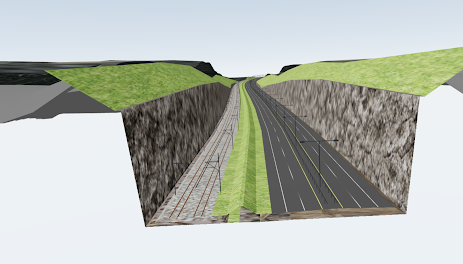
Example: Determine the amount of rock excavation required for this project, and calculate the associated carbon footprint from the surplus masses.
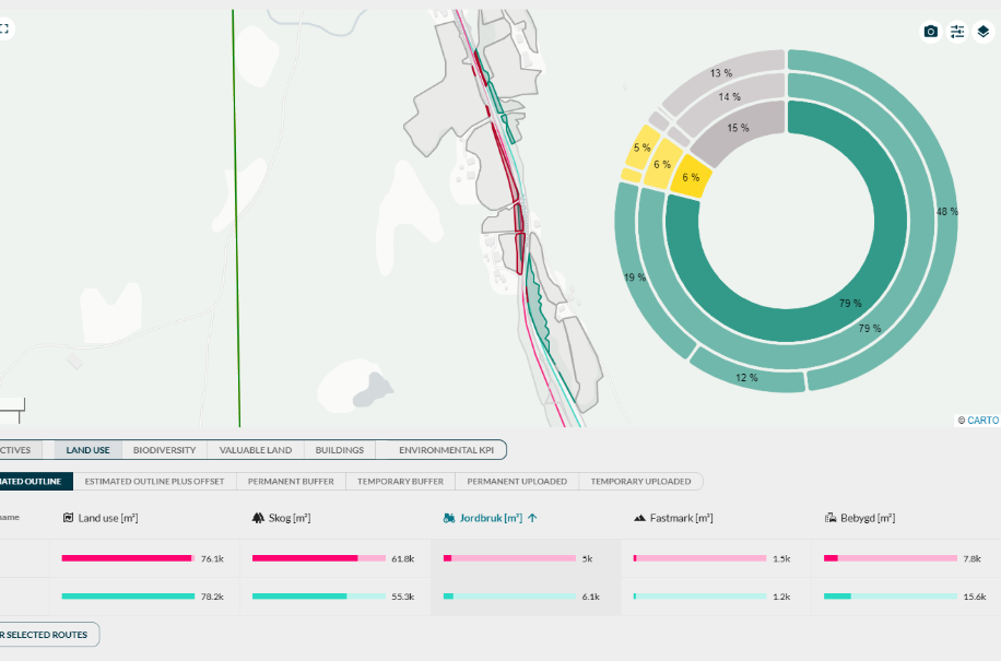
Automated Land Use Analysis
Instantly estimate and visualize how your projects impact land use based on land cover data.
Example: Determine how many square meters of cropland are affected by this road proposal.
Instant Environmental Impact Assessments
Use Infraspace to instantly analyze your proposals for environmental impact. Gain insights on visibility, valuable land take, barrier effects, level of reuse, and more.
Example: Determine which of your alternatives is the least visible in the landscape.
Customer story: Norconsult & Nye Veier (RV4)
Read case study
Road and highway planning FAQ
Common questions about AI-assisted corridor and alignment planning for roads and highways.
How does AI optimize road alignments?
AI optimizes road alignments by combining terrain models, GIS data, geometric constraints, cost assumptions, and environmental criteria.
The system generates, optimizes and compares alternatives to identify alignments that can reduce cost, improve mass balance, reduce land take, or lower environmental impact.
What is corridor optimization?
Corridor optimization is the process of finding the most suitable route or corridor for infrastructure such as roads, railways, pipelines, or power lines.
It considers terrain, geometry, environmental constraints, land use, cost, CO2, and constructability.
What is mass balance optimization?
Mass balance optimization aims to reduce the surplus or deficit of excavated materials by improving the relationship between cut and fill.
Better mass balance can reduce transport, disposal, imported materials, cost, and CO2 emissions.
Can Infraspace analyze existing proposals?
Yes. Teams can upload existing alignments from conventional design tools and analyze them using the same KPI framework as AI-generated proposals.
This makes it possible to compare traditional designs and AI-generated alternatives on a shared data foundation.
Learn more
How is Infraspace different from Autodesk Civil 3D?
Autodesk Civil 3D is primarily used to manually design and document detailed road and site models. Infraspace focuses on early-stage alternative generation, automated KPI analysis, and rapid comparison of many corridor options before detailed design begins.
Teams often use Infraspace for optioneering and decision support, then export alignments and context to Civil 3D or other tools for detailed engineering.
Learn more
How does Infraspace compare to Autodesk InfraWorks and Trimble Quantm?
All three support early infrastructure planning, but with different emphasis. Autodesk InfraWorks is a desktop tool for conceptual design and visualization in rich 3D context models. Trimble Quantm is desktop alignment-planning software focused on routing of road and rail corridors. Infraspace is a cloud-based platform with AI-assisted generative design that rapidly generates, optimizes and compares alternatives with KPIs and 3D visualizations — based on construction cost, earthworks, land use, and environmental impact for different infrastructure types.
Infraspace differentiates itself in three key ways:
- Unique AI technology — The L.IN.E.A engine explores thousands of corridor alternatives against terrain, constraints, and project objectives in minutes—making you confident in moving forward with your choices.
- Accessible web-based platform — Project data, 3D models, and KPI dashboards live in the browser so planners, engineers, and stakeholders can collaborate without everyone using specialist desktop software.
- Multi-objective optimization — Create and optimize alternatives based on multiple objectives—such as minimizing construction cost and CO₂, reducing earthworks and mass imbalance, and lowering environmental impact at the same time.
What KPIs can Infraspace calculate?
Infraspace can calculate KPIs such as construction cost, CO2, earthworks volumes, mass balance, area usage, land take, viewshed, environmental metrics, affected buildings, biodiversity considerations, and required structures such as bridges and tunnels.
From days to minutes
Norconsult and Nye Veier used Infraspace on National Road (Rv.) 4 Gjøvik–Mjøsbrua to evaluate, optimize, and compare alignment alternatives—cutting analysis time from days to minutes before options were locked in.
Read the Norconsult and Nye Veier RV4 case study